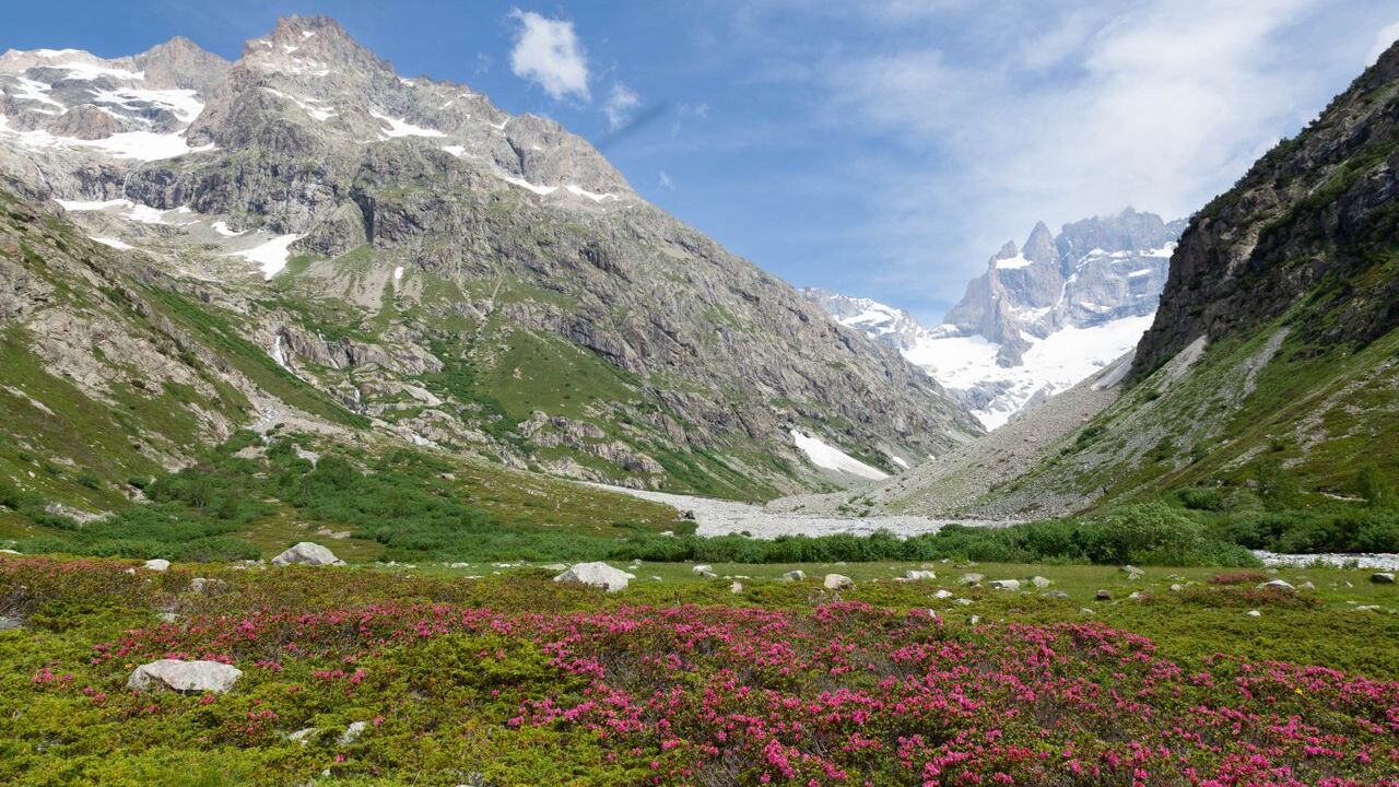
The places to visit in Uttarakhand split cleanly between Garhwal in the west and Kumaon in the east, and almost nobody does both well in one trip. The Valley of Flowers is open only from June to October, a narrower window than any shrine on the Char Dham. Pick a division, then pick between shrines, hill towns, parks and the high country.
One naming point clears up the circuit most people come for. The original Char Dham is Badrinath, Dwarka, Puri and Rameswaram, four shrines at the four corners of India. The Uttarakhand circuit is the Chota Char Dham, and Badrinath is the only shrine on both lists. The guide to preparing for travelling in India takes the practical questions, and this takes the places.
Places to visit in Uttarakhand
- The four shrines. Yamunotri, Gangotri, Kedarnath and Badrinath, all in Garhwal, open from late April or early May to November.
- The five prayags. Devprayag, Rudraprayag, Karnaprayag, Nandaprayag and Vishnuprayag, on the same roads as the shrines.
- The Kumaon hill towns. Nainital, Almora, Ranikhet, Kausani, Binsar and Munsiyari.
- Corbett. India's oldest national park, in Nainital district.
- The Valley of Flowers and Nanda Devi. A UNESCO World Heritage Site in Chamoli district.
- Chopta and Tungnath. The Panch Kedar circuit, which is not the Char Dham and is almost never mentioned alongside it.
- Rishikesh, Haridwar and Mussoorie. The Garhwal towns most itineraries start or end in.
The Char Dham and the Panch Prayag
Four shrines and five river confluences, all in Garhwal, on one road system that runs west to east.
- Yamunotri. 3,291 metres, reached on a walk of about 6 kilometres from Janki Chatti.
- Gangotri. 3,100 metres, and the only shrine with a road to the temple door.
- Kedarnath. 3,553 metres, the highest, about 18 kilometres on foot from Gaurikund.
- Badrinath. 3,300 metres, with a road to the temple, and the shrine on both Char Dham lists.
- Devprayag. Where the Bhagirathi meets the Alaknanda and the river takes the name Ganga. The water at Gangotri is the Bhagirathi, not the Ganga.
- Gaumukh. The glacier snout about 18 kilometres beyond Gangotri, which is the actual source of the Bhagirathi.
- The winter seats. Kharsali, Mukhba, Ukhimath and Joshimath, where the deities are carried for the closed months.
Nainital, Almora and the Kumaon hill towns
Lower, greener, and open all year, which is the main practical difference from Garhwal.
- Nainital. Around the lake, and the judicial capital of the state because the High Court sits here.
- Almora. A ridge town and the best market in Kumaon for craft.
- Ranikhet and Kausani. Quieter, with the long Himalayan view that gets photographed from Kausani.
- Binsar. A wildlife sanctuary on a forested ridge above Almora.
- Munsiyari. High Kumaon, close to the Panchachuli peaks, and the source of the rajma.
- Nanda Devi. 7,817 metres, the highest peak in the state, visible from several of these ridges.
- Why they suit a first trip. No altitude problem, no seasonal closure, and the driving is shorter.
The craft towns are what our eight day cultural journey through Kumaon is built around, rather than the viewpoints.
Corbett and the national parks
- Corbett. India's oldest national park, established in 1936 as Hailey National Park. The core park covers about 520 square kilometres, in Nainital district.
- Project Tiger. The Corbett Tiger Reserve was created under it in 1973, and the wider reserve runs to about 1,318 square kilometres.
- The zones. Dhikala, Bijrani, Jhirna, Sonanadi, Durgadevi and Dhela, each entered separately and booked separately.
- When to go. November to February is the usual recommendation.
- Rajaji. The other large park, near Haridwar and Rishikesh, and far less visited.
- Binsar and Askot. Smaller sanctuaries in Kumaon, worth a day rather than a trip.
- What the age means. Corbett predates Indian independence and Project Tiger both, which is why its history is the history of Indian conservation.
Valley of Flowers, Nanda Devi and the high country
A UNESCO World Heritage Site in Chamoli district, and the shortest usable season of anything in the state.
- The season. June to October only. Snow-bound for six to seven months, between late October and late March.
- The altitude. The valley sits between about 3,352 and 3,658 metres.
- What grows there. 498 flowering species, out of 520 higher plants recorded in the park.
- Getting there. From Govindghat, a short drive then a trek through Ghangaria, about 17 kilometres in total.
- Hemkund Sahib. On the same trail from Ghangaria, and covered by the same Char Dham registration requirement.
- Auli. The ski slope above Joshimath, which is the same high country in its winter form.
- The relationship between terrain and settlement here is the same one at work across the hills.
Chopta, Tungnath and the Panch Kedar
The circuit that sits beside the Char Dham and is almost never sold with it. Kedarnath is not a standalone shrine, it is the first of five.
- The Panch Kedar order. Kedarnath, Tungnath, Rudranath, Madhyamaheshwar and Kalpeshwar.
- Tungnath. 3,680 metres in Rudraprayag district, the third Kedar and the highest of the five.
- The claim worth checking. Tungnath is widely sold as the highest Shiva temple in the world. The careful description is one of the highest, and it is certainly the highest of the Panch Kedar.
- Chopta. The road head, about 5 kilometres below Tungnath, and a four to five hour walk up.
- Chandrashila. The ridge about a kilometre above Tungnath, which is where the view is.
- Why it belongs on an itinerary. It is higher than three of the four Char Dham shrines and carries a fraction of the traffic.
The state rewards picking one division and one kind of place, rather than a route that touches all four and arrives at none of them. Customised tours is where the shrines, the hill towns and the seasons get arranged around one another.
Also Read
- Things to Know Before Planning a Trip to Uttarakhand
- Destinations in India: Discovering Places Through Culture, Stories and Everyday Life
- How Festivals Temporarily Reshape Indian Destinations
Frequently Asked Questions
Why is the Uttarakhand circuit called the Chota Char Dham?
Because the original Char Dham is a different set of four shrines, at the four corners of India: Badrinath, Dwarka, Puri and Rameswaram. The Uttarakhand circuit of Yamunotri, Gangotri, Kedarnath and Badrinath was named Chota to distinguish it. Badrinath is the only shrine on both lists.
When is the Valley of Flowers open?
June to October only. The valley is snow-bound for six to seven months of the year, roughly late October to late March, which gives it the shortest season of any major site in the state. It is reached on a trek of about 17 kilometres from Govindghat through Ghangaria.
Is Corbett the oldest national park in India?
Yes. It was established in 1936 as Hailey National Park and later renamed after Jim Corbett. The core park covers about 520 square kilometres in Nainital district, and the wider Corbett Tiger Reserve, created under Project Tiger in 1973, runs to about 1,318 square kilometres.
Where does the river Ganga begin?
At Devprayag, where the Bhagirathi meets the Alaknanda. The river at Gangotri is the Bhagirathi, and its physical source is the Gaumukh glacier snout about 18 kilometres beyond the shrine. The name Ganga belongs to the river only from Devprayag downstream.